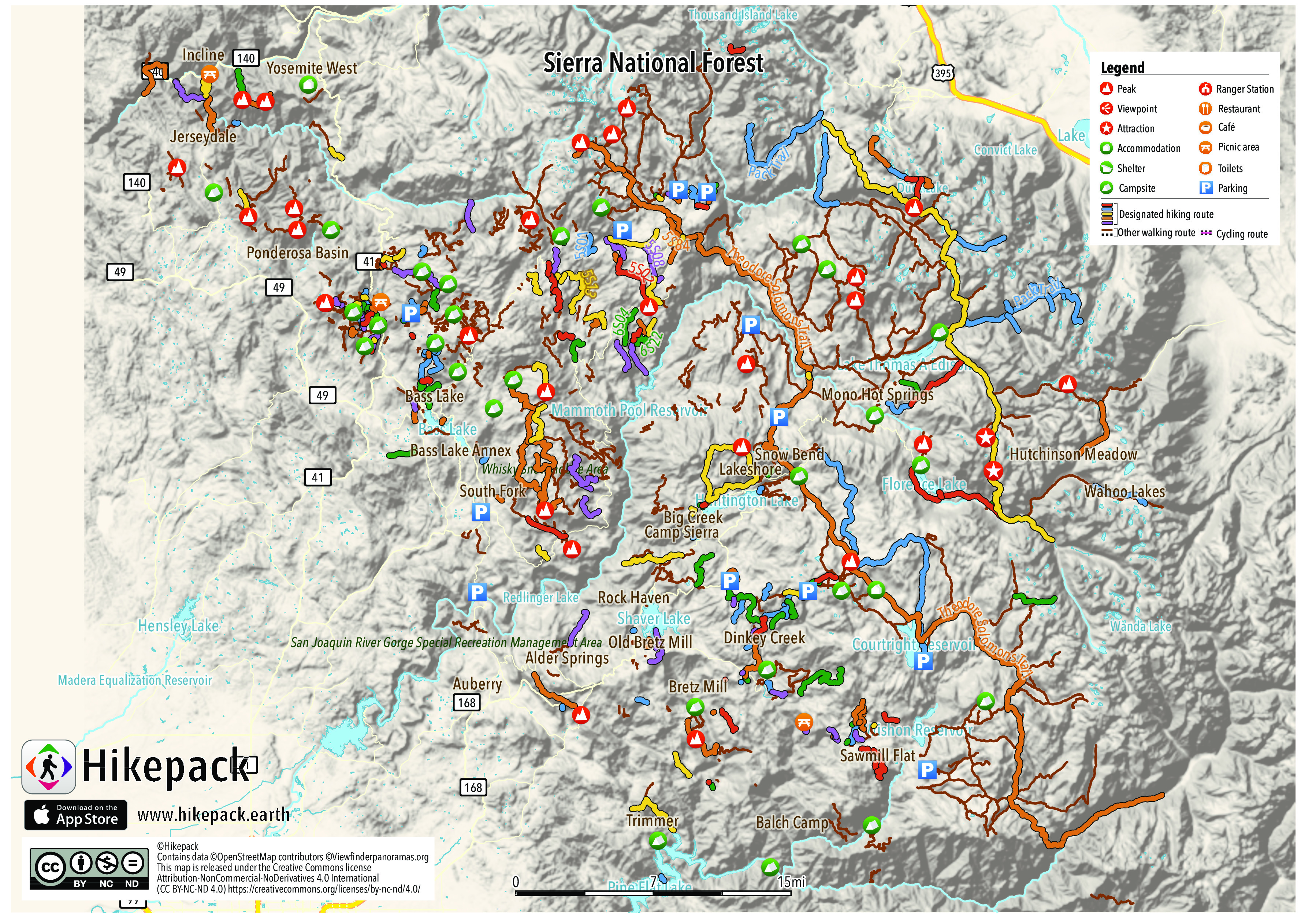
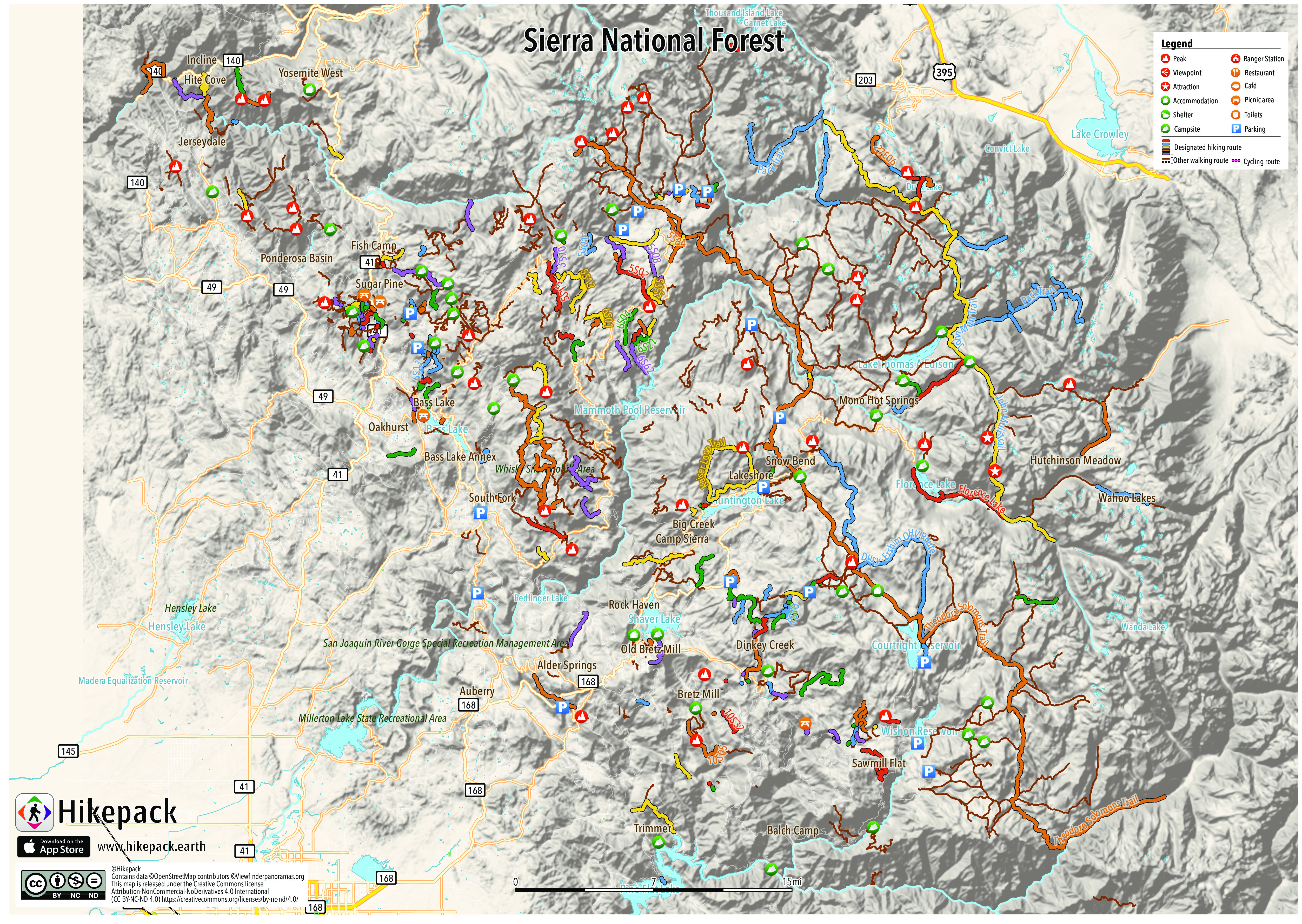
Sierra National Forest
681 Trails
587 POIs
191 Peaks
84 Campsites
21 Picnic Sites
6 Viewpoints


Description
Sierra National Forest is located on the western slope of the Sierra Nevada and elevations reach 13,986 ft (4,263 m). There are 1,800 mi (2,900 km) of streams, 480 lakes, 11 reservoirs, and 63 campgrounds in the forest.
Trails in the Hikepack map
- To Campsite
- 10S05
- 10S10
- 10S14
- 10S17M
- 10S18
- 10S37
- 10S49
- 10S51a
- 10S69K
- 10S69L
- 243
- 244a
- 26E38
- 27E06
- 27E06 (Approx)
- 27E10
- 4S60A
- 5S01
- 5S02
- 5S05
- 5S08
- 5S10
- 5S11
- 5S13
- 5S15
- 5S22
- 5S43
- 5S55
- 5S58
- 5S65
- 5S84
- 5S88
- 5S93
- 5S95
- 65S02
- 6S01
- 6S04
- 6S07
- 6S11
- 6S11X
- 6S13
- 6S13B
- 6S13C
- 6S13X
- 6S22
- 6S22C
- 6S22H
- 6S22Y
- 6S23Y
- 6S50
- 6S58
- 6S62
- 6S83
- 6S88
- 6S90F
- 7S82
- Actual Mammoth Crest Route
- Allen Road
- BLT
- Bald Mountain OHV Trail
- Beal Fire Road
- Bear Creek Cutoff Trail
- Bear Creek Trail
- Bishop Creek Trail
- Black Point Road
- Blue Canyon Road
- Bob's Flat Trail
- Bull Buck Loop
- Bypass
- Cascadel Road
- Castle Pk
- Chawanakee Road
- Chimney Trail Loop
- Cody
- Crane Valley Road
- Crater Creek Trail
- Dinkey Lakes Trail
- Dot
- Douglas Ranger Station Road
- Dusy-Ershim OHV Route
- EZee
- Edison Point Trail
- FSR 9S10
- FSR 9S45
- Falcon View Road
- Florence Fry
- Florence Lake
- Forest Route 10S16F
- Forest Route 10S20
- Forest Route 10S20A
- Forest Route 10S20C
- Forest Route 10S24 (Ross Crossing Road)
- Forest Route 10S38
- Forest Route 10S66
- Forest Route 10S70
- Forest Route 10S70A
- Forest Route 10S70B
- Forest Route 10S73A
- Forest Route 11S12
- Forest Route 11S12B
- Forest Route 11S12D
- Forest Route 11S17
- Forest Route 11S17C
- Forest Route 11S19
- Forest Route 11S40G
- Forest Route 25E206
- Forest Route 25E306
- Forest Route 4S02
- Forest Route 4S60
- Forest Route 4S61
- Forest Route 5S02
- Forest Route 5S02E
- Forest Route 5S30
- Forest Route 5S30C
- Forest Route 5S33
- Forest Route 5S502
- Forest Route 5S67
- Forest Route 8S02
- Forest Route 9S09
- Forest Route 9S14
- Forest Route 9S23
- Forest Route 9S23T0.04
- Gigantea Campground Loop
- Graveyard of the Giants
- Half Mile
- Hall
- Hell For Sure Pass Trail
- Henness Ridge Drive
- Hites Cove 4W-Dr Road
- Hites Cove OHV Trail
- Hites Cove Trail
- Hites Mine Road
- Home Creek Lane
- Idylwild Lane
- Incline Road
- Iron Creek Trail
- John Muir Trail
- Kaiser Loop Trail
- Kempe
- Kiser
- Lake Trail
- Left Meadow Trail
- MMTB
- Mammoth Trail
- Mammoth Trailhead Parking Lot
- Manzanita Road
- Martin
- Mc Kinley Grove Road
- McGee Pass Trail
- McKinley Grove Road
- McSwain Road
- Mystery Lake Trail
- NOT FINISHED
- Nevins Road
- OHV trail
- Old Railroad Grade Road
- PCT - California Section H
- Pacific Crest Trail
- Pack Trail
- Peachtree Bar
- Pika Lake Trail
- Pine Creek Trail
- Piute Trail
- Powerline
- RS01
- RS10
- RS10P
- RS401
- RS405
- RS62
- Red Creek Road
- Right Meadow Trail
- Road 8007
- Road 8009
- Road 8029
- Rock Creek Road (Forest Route 9S09)
- Ross Crossing Road
- Route up Ritter
- S. Express
- Sallie Keys
- Shady
- Shawdow of the Giant National Recreation Trail
- Shuteye OHV 6S59
- Simmons
- Single
- Soaproot Saddle Road
- South Meadow Drive
- Squarenail Approach
- Stagecoach
- Standard Mill Road
- Star Lake Road
- Sugarloaf Road
- Sunflower
- Theodore Solomons Trail
- Tiffany Pines
- Tollhouse Traverse Approach
- Trail to USFS Fire Station
- Trail to campsites
- Trails End Road
- Tuolumne River
- USGS
- Walking Path
- Whipering Way
- Whisky Snowmobile Trails Road
Attractions in the Hikepack map
- 29
- Alder Springs
- Angle Falls
- Auberry
- Backbone Mountain
- Badger Flat Campground
- Badger Flat Group Campground
- Badger Flat Trailhead
- Balch Camp
- Bald Mountain
- Balloon Dome
- Banner Peak
- Barnes Mountain
- Bass Lake
- Bass Lake Annex
- Bear Dome
- Bear Mountain
- Big Creek
- Big Ed
- Big Sandy Bluff
- Black Butte
- Black Peak
- Black Point
- Blackcap Mountain
- Blackrock Reservoir Campground
- Blue Sky Cafe
- Bob's Market
- Bowler Group Camp
- Branford Mountain
- Bretz Campground
- Bretz Mill
- Brown Cone
- Brown Peak
- Bull Buck Tree
- Burrough Mountain
- Camino Falls
- Camp Chawanakee
- Camp Kern
- Camp Mirimichi
- Camp Olijato
- Camp Sierra
- Canyon Bar & Grill
- Cape Horn
- Cascadel Point
- Cascadel Woods
- Castle Peak
- Cats Head Mountain
- Cattle Mountain
- Cedar Crest
- Cedar House Restaurant
- Cedar Lodge
- Chilkoot Campground
- Chinese Peak
- Chiquito Pass
- Chiquito Trailhead Parking
- Chowchilla Mountain
- Chuck Pass
- Cockscomb
- College Campground
- Corlieu Falls
- Corral Mountain
- Crow Peak
- Davis Mountain
- Devil Peak
- Devils Table
- Devils Top
- Dinkey Creek
- Dinkey Dome
- Dinkey Mountain
- Dogtooth Peak
- Dora Belle
- Dorabelle Campground
- Double Peak
- Dowville Picnic Area
- Ducey’s On The Lake
- Eagle Peak
- East Guest Parking Lot
- Eastwood Sno-Park
- Edison Ferry Pickup
- Edison Point Trailhead
- Elliot House Bed & Breakfast
- Ely Mountain
- Enchanted forest
- Feather Peak
- Feliciana Mountain
- Fernandez Pass
- Fire lookout
- Firepit and stream near by
- Fish Camp
- Fish Camp Post Office
- Fleming Mountain
- Flume Peak
- Foerster Peak
- Fresno Dome
- Fuller Buttes
- Gaggs Camp
- Garlic Falls
- Gemini
- Goat Meadow Snow Play Mountain
- Goat Mountain
- Gold Arrow Camp
- Graham Mountain
- Grand Bluff
- Graveyard Peak
- Green Mountain
- Greys Mountain
- Hacker Mountain
- Hall Mountain
- Heart Lake
- Hite Cove
- Hoffman Mountain
- Hog Mountain
- Hogan Mountain
- Hotel & Cabins office
- Hungry Hunter
- Huntington Lake
- Huntington Lake Resort
- Hutchinson Meadow
- Incline
- Indian Flat Day Use
- Infant Buttes
- Iron Mountain
- Isberg Pass
- Iva Bell Hot Springs
- Jackass Butte
- Jackass Dike
- Jackass Lakes Trailhead
- Jackass Meadow Campground
- Jackass Rock
- Jerseydale
- John Muir Trail
- Jump Off Point
- Junction Bluffs
- Junction Butte
- Kaiser Peak
- Kamook Staging Area
- Kerckhoff Dome
- Kings Castle
- Kirby Peak
- Kirch Flat Campground
- Knotty Pines Cabins
- Kokanee Work Center
- Lacy Camp
- Lakeshore
- Left Meadow Trail
- Lerona
- Limestone Campsite
- Lion Point
- Little Shuteye Peak
- Lodge
- Lone Seqouia
- Long Mountain
- Long Top
- Lookout Point
- Loper Peak
- Lost Peak
- Lower Jackass Lake Campground
- Luck Point
- MAXON TH
- Madera Peak
- Marble Point
- Marie Lake
- Mathews Mill
- Maxson Dome
- Mc Kinley Botanical Area
- Meadow Lakes
- Mens
- Merriam Peak
- Miami Mountain
- Midge Creek Campground
- Midpines
- Midpines Country Store
- Mini Mart
- Mono Creek Overflow Campground
- Mono Creek Trailhead Parking
- Mono Hot Springs
- Mono Hot Springs Campground
- Mono Hot Springs Resort
- Mono Pass
- Mono Rock
- Moore Boys Camp
- Mormon Hill
- Mount Abbot
- Mount Crocker
- Mount Davis
- Mount Gabb
- Mount Givens
- Mount Goethe
- Mount Harrington
- Mount Henry
- Mount Hilgard
- Mount Hooper
- Mount Hopkins
- Mount Humphreys
- Mount Huntington
- Mount Hutton
- Mount Ian Campbell
- Mount Izaak Walton
- Mount Julius Caesar
- Mount Mills
- Mount Raymond
- Mount Reinstein
- Mount Seneger
- Mount Shinn
- Mount Stanford
- Mount Stevenson
- Mount Tom
- Musick Mountain
- Narrow Gauge Inn
- Nelson Mountain
- Norris Lake Trailhead
- North Fork
- North Fork Post Office
- North Rock
- Oakhurst
- Ockenden
- Old Bretz Mill
- Overflow Parking
- PG&E Campground
- Pack Station
- Patterson Bluffs
- Patterson Mountain
- Peckinpah Mountain
- Pilot Knob
- Pilot Peak
- Pincushion Peak
- Pine Creek Pass
- Pineridge
- Pines Village Pizzeria
- Pinoche Peak
- Pit toilet
- Piute Pass
- Piyau Dome
- Ponderosa Basin
- Post Peak
- Post Peak Pass
- Pumice Butte
- Quartz Mountain
- Rancheria Amphetheater
- Rancheria Campground
- Rancheria Trialhead
- Recess Peak
- Red Bud Picnic Area
- Red Mountain
- Red Rock Falls
- Red Slate Mountain
- Red and White Mountain
- River Rock Cafe
- Rock Haven
- Rodgers Peak
- Rose Lake
- Royce Peak
- Saddle Mountain
- Sadler Peak
- Sallie Keyes Lake
- Saw & Mill Restaurant
- Sawmill Flat
- Seven Gables
- Sharktooth Peak
- Shaver Lake
- Shaver Lake Heights
- Shaver Lake Pizza
- Shaver Lake Post Office
- Shaver Lake Village Hotel & Cabins
- Shaver free campsite
- Shuteye Peak
- Sierra Cedars
- Sierra-Mono Indian Museum
- Silver Knob
- Silver Peak
- Sing Peak
- Sivels Mountain
- Snow Bend
- Source Point
- South Fork
- South Fork Bluffs
- South Guest Parking Lot
- Spanish Mountain
- Speckerman Mountain
- Sugar Pine
- Sugarloaf Hill
- Sugarpine Hill
- Summerdale Campground
- Sunset Point
- Sweetwater Point
- Tamarack Mountain
- Tenaya Lodge
- Tennessee Point
- The Falls Restaurant
- The Logger's Retreat
- The Pines
- The Pines Resort
- The Village Suites
- Thornberry Mountain
- Three Island Lake
- Three Sisters
- Timber Knob
- Timberloft Pizzaria
- Tollhouse Rock
- Trailhead Parking
- Trimmer
- Trimmer Campground
- Turret Peak
- Twin Falls
- Upper Chiquito Campground
- Upper Sallie Keyes Lake
- Valet Parking
- Vermilion Cliffs
- Vermilion Valley Campground
- Vernal Fall
- Visitor Center
- Visitor Parking
- Volcanic Cone
- Volcanic Knob
- Voyager Rock Camping Area
- Wahoo Lakes
- Wamelo Rock
- Ward Mountain
- Whiskers Camp
- Whisky Falls
- White Bark Scenic Viewpoint
- White Chief Mountain
- Willow Creek Trail
- Womens
- Yosemite West
- Yosemite West / Mariposa KOA
- Yosemite West Lodging, Inc.
- Yosemite np free campsite
- Zingheim Heights
Copyright
The PDF and JPG maps are released by Hikepack under the Creative Commons license Attribution-NonCommercial-NoDerivatives 4.0 International (CC BY-NC-ND 4.0)
https://creativecommons.org/licenses/by-nc-nd/4.0/.
Contains data ©OpenStreetMap contributors (https://www.openstreetmap.org/copyright) under the Open Database License (https://opendatacommons.org/licenses/odbl/). Topographic map based on elevation data from Viewfinderpanoramas.org (Jonathan de Ferranti). Aerial imagery available from the U.S. Geological Survey. Description text is available under the Creative Commons Attribution-ShareAlike 3.0 Unported License from Wikipedia (https://en.wikipedia.org/wiki/Wikipedia:Text_of_Creative_Commons_Attribution-ShareAlike_3.0_Unported_License). Cover image ©Smack https://en.wikipedia.org/wiki/List_of_U.S._National_Forests#/media/File:Lake_of_the_Lone_Indian_JMW.jpg Public Domain