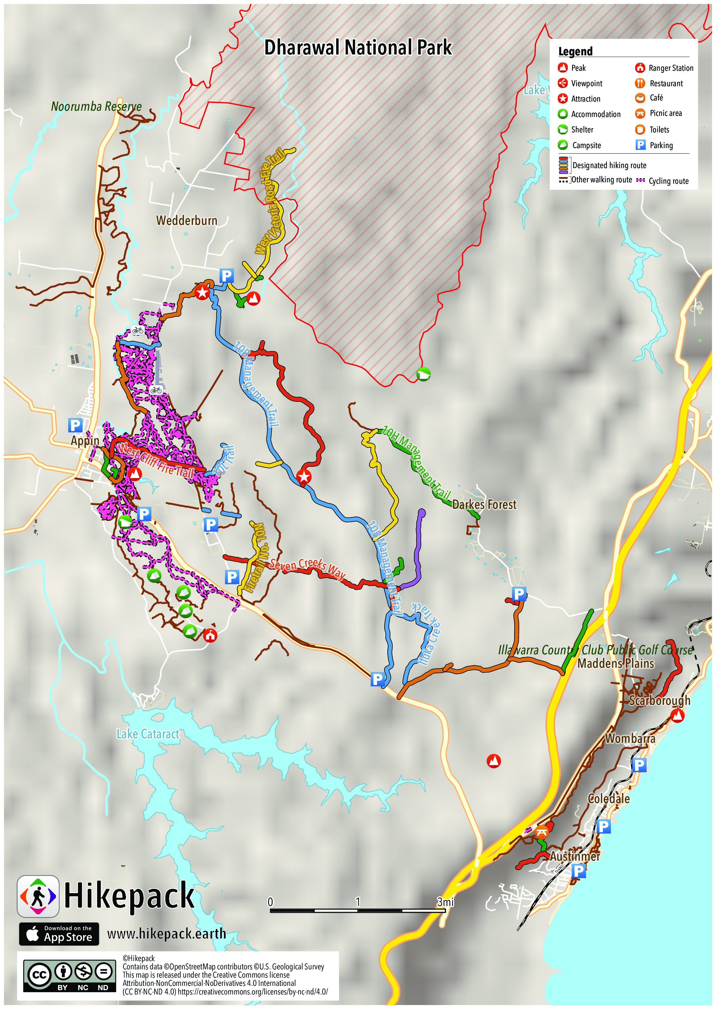
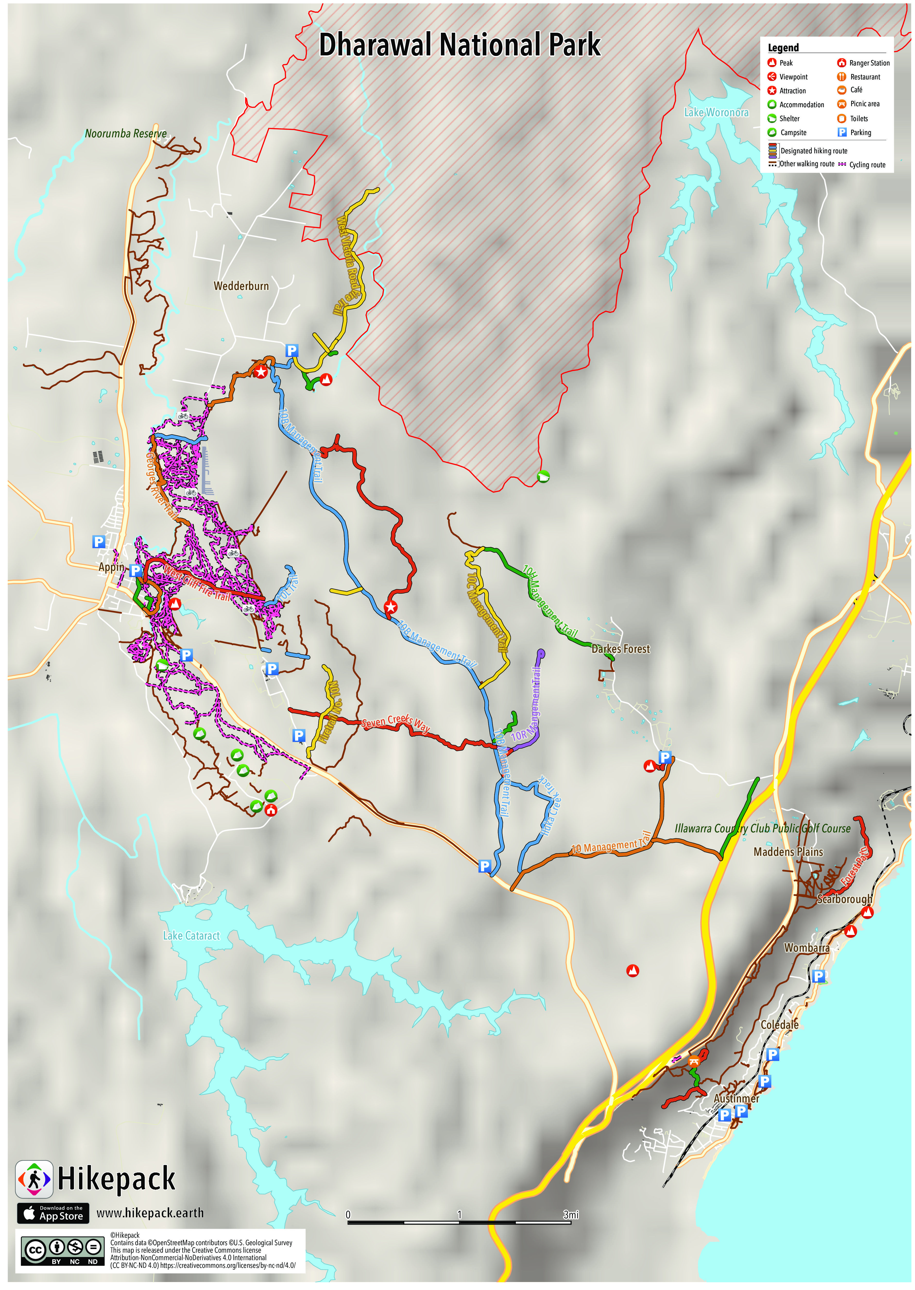
Dharawal National Park
178 Trails
321 POIs
1 Peak
14 Campsites
24 Picnic Sites
7 Viewpoints


Description
The Dharawal National Park is a protected national park that is located in the Illawarra region of New South Wales, in eastern Australia. The 6,508-hectare (16,080-acre) national park is situated between the Illawarra Range and the Georges River and is approximately 45 kilometres (28 mi) south west of Sydney. There are three entry points to the park: from the east through Helensburgh, from the north through Campbelltown and from the south through Appin. The national park covers almost both the O’Hares and Stokes Creek catchments. It contains significant biodiversity and ecosystems as well as Aboriginal culturally significant sites. It has high conservation significance within the region, especially due to the low disturbance within the park and limited public access. The landscape varies from gorges and waterfalls to upland swamps to sandstone woodland, rainforests, and eastern gully forests. The residents of the park include koalas, wallabies, wallaroos, platypuses, potoroos, pygmy possums and many more animal species. The conservation objectives of the park are to maintain the natural and cultural heritage, provide education and research opportunities as well as providing some recreation activities.
Trails in the Hikepack map
- 10 Management Trail
- 10A Management Trail
- 10B Management Trail
- 10C Management Trail
- 10D Management Trail
- 10H Management Trail
- 10L Trail
- 10O Trail
- 10P Management Trail
- 10Q Management Trail
- 10R Mangement Trail
- 10R Mangement Trail (disused)
- 10T Management Trail
- 10U Mangement Trail
- 10Z Management Trail
- Church Fire Trail
- Firetrail No. 10N
- Forest Path
- Georges River Trail
- Gibson Track
- Iluka Creek Track
- Jingga Track
- Maddens Falls Walk
- Market Fire Trail
- O'Hares Creek Lookout Track
- Princes Highway
- Princes Motorway
- Seven Creeks Way
- Stuckey Place
- Sublime Point Track
- Victoria Road Trail
- Wedderburn Fire Trail
- West Cliff Fire Trail
- West Victoria Road Fire Trail
- Woodward Track
Attractions in the Hikepack map
- 10
- 100
- 102
- 10Q
- 10Z
- 7F
- 7G
- 7H
- Appin
- Appin Post Office
- Austi Cafe
- Austinmer
- Austinmer Newsagency
- Austinmer Post Office
- Cape Horn
- Coledale
- Coledale Beach Camping Reserve
- Coledale Newsagency
- Coledale Pool
- Darkes Forest
- Dharawal National Park
- Duty Wardens
- Headlands Hotel
- Loddon Falls
- Maddens Falls
- Maddens Falls Walk
- Maddens Plains
- Minerva Pool
- Minerva Pool Lookout
- O'Hares Creek Lookout
- O'hares creek
- Sandy Plateau
- Scarborough
- Shells Diner
- Sublime Point Cafe
- Sublime Point Lookout
- Wedderburn
- Wombarra
- Wombarra Rock Pool
Copyright
The PDF and JPG maps are released by Hikepack under the Creative Commons license Attribution-NonCommercial-NoDerivatives 4.0 International (CC BY-NC-ND 4.0)
https://creativecommons.org/licenses/by-nc-nd/4.0/.
Contains data ©OpenStreetMap contributors (https://www.openstreetmap.org/copyright) under the Open Database License (https://opendatacommons.org/licenses/odbl/). Topographic map based on elevation data from the U.S. Geological Survey and NASA (SRTM 1 Arc-Second Global). Description text is available under the Creative Commons Attribution-ShareAlike 3.0 Unported License from Wikipedia (https://en.wikipedia.org/wiki/Wikipedia:Text_of_Creative_Commons_Attribution-ShareAlike_3.0_Unported_License). Cover image ©Doug Ford https://en.wikipedia.org/wiki/File:Dharawal_National_Park.jpg CC BY 2.0 (https://creativecommons.org/licenses/by/2.0/).