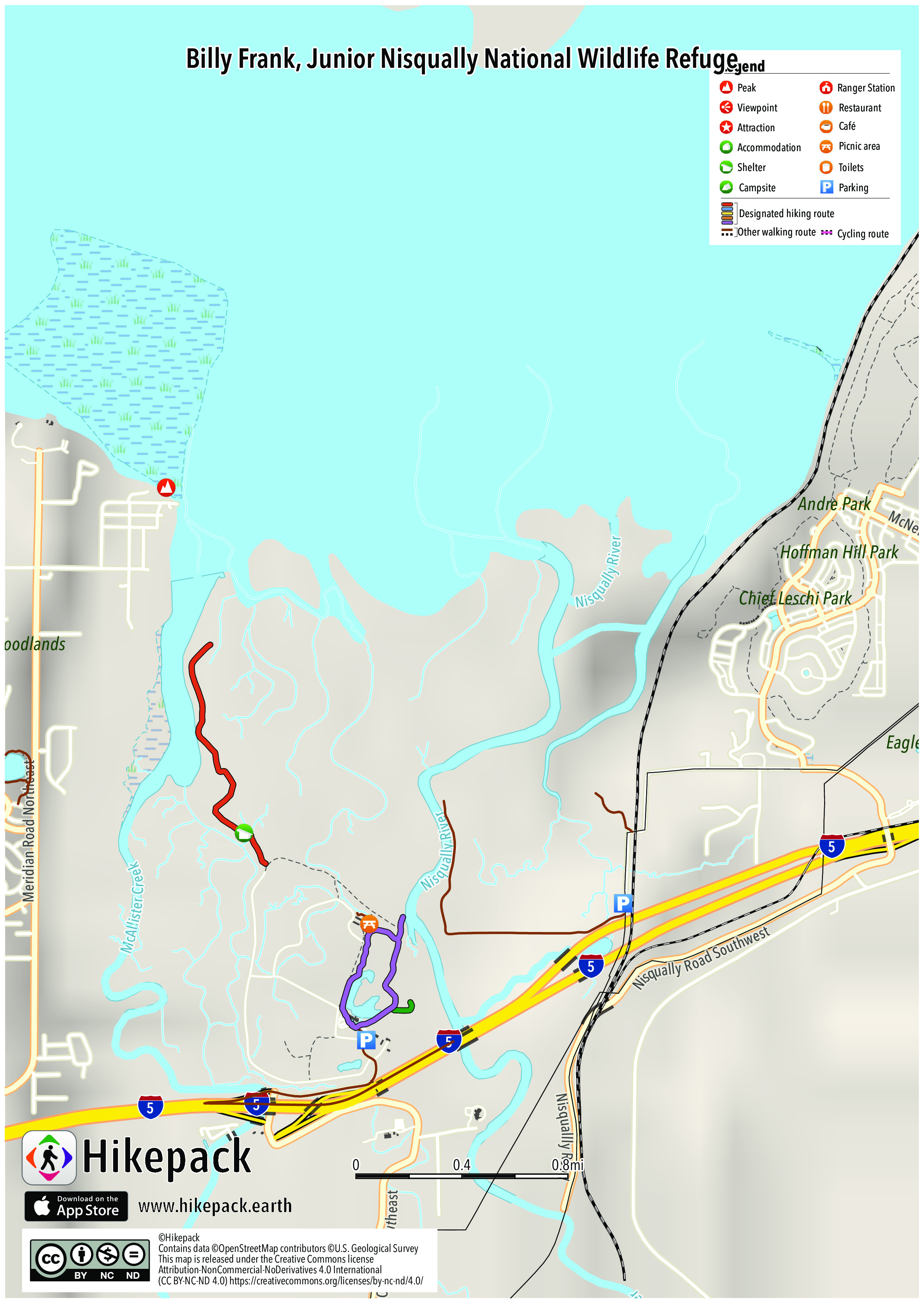
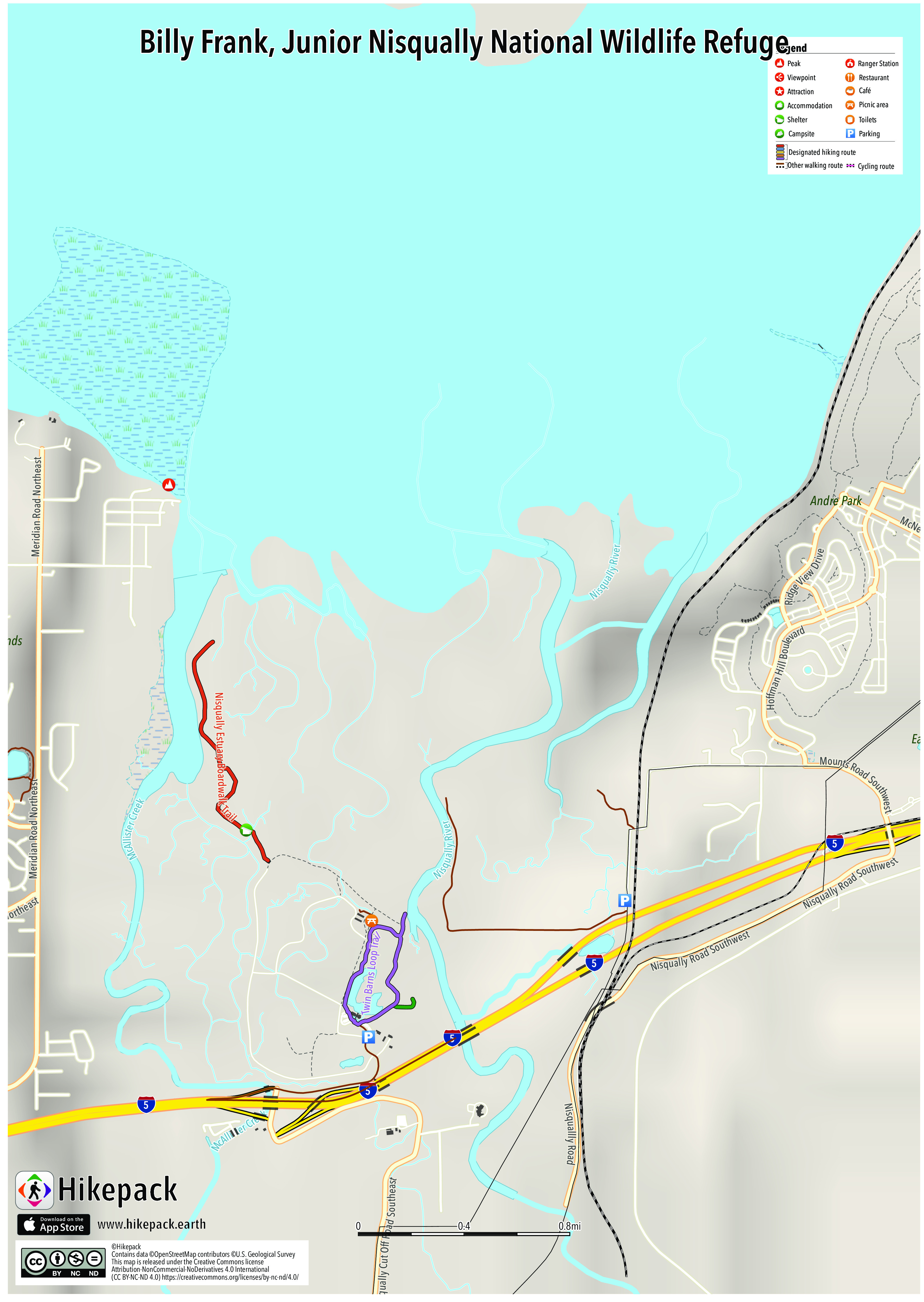
Billy Frank, Junior Nisqually National Wildlife Refuge
15 Trails
26 POIs
1 Picnic Site
6 Viewpoints


Description
The Billy Frank Jr. Nisqually National Wildlife Refuge is a wildlife preserve operated by the United States Fish and Wildlife Service on the Nisqually River Delta near Puget Sound in northeastern Thurston County, Washington and northwestern Pierce County, Washington. The refuge is located just off Interstate 5, between the cities of Tacoma and Olympia. The wildlife refuge is home to the Nisqually River Delta, which has the unique status as Washington's largest relatively undisturbed estuary. The confluence of the freshwater Nisqually River and the saltwater south Puget Sound has created a variety of unique environments, each rich in nutrients and natural resources for the local wildlife. The delta provides habitats for more than 300 different species of fish and wildlife. Over 20,000 birds, made up of 275 different migrating species, use the freshwater marshes and grasslands for breeding, resting or wintering. The most abundant bird types include raptors, shorebirds and songbirds. Larger animals such as hawks and coyotes feast in the grassland due to the presence of mice and voles. The riparian woodland and brush habitats contain many amphibians, mammals and reptiles.
Trails in the Hikepack map
- Nisqually Estuary Boardwalk Trail
- Riparian Forest Overlook Trail
- Twin Barns Loop Trail
Attractions in the Hikepack map
- Luhr Beach Boat Launch
- McAllister Creek Viewing Platform
- Nisqually Head
- Nisqually Reach Nature Center
- Nisqually River Overlook
- Norm Dicks Visitor Center
- Observation Tower
- Puget Sound Viewing Platform
- Riparian Forest Overlook
- Seasonal Trail Closure
- Shannon Slough Blind
- Twin Barns Observation Platform
- Visitor Parking East
Copyright
The PDF and JPG maps are released by Hikepack under the Creative Commons license Attribution-NonCommercial-NoDerivatives 4.0 International (CC BY-NC-ND 4.0)
https://creativecommons.org/licenses/by-nc-nd/4.0/.
Contains data ©OpenStreetMap contributors (https://www.openstreetmap.org/copyright) under the Open Database License (https://opendatacommons.org/licenses/odbl/). Topographic map based on elevation data from the U.S. Geological Survey. Aerial imagery available from the U.S. Geological Survey. Description text is available under the Creative Commons Attribution-ShareAlike 3.0 Unported License from Wikipedia (https://en.wikipedia.org/wiki/Wikipedia:Text_of_Creative_Commons_Attribution-ShareAlike_3.0_Unported_License). Cover image ©Walter Siegmund https://commons.wikimedia.org/wiki/File:Nisqually_NWR_28077.JPG CC BY 2.5 (https://creativecommons.org/licenses/by/2.5/).