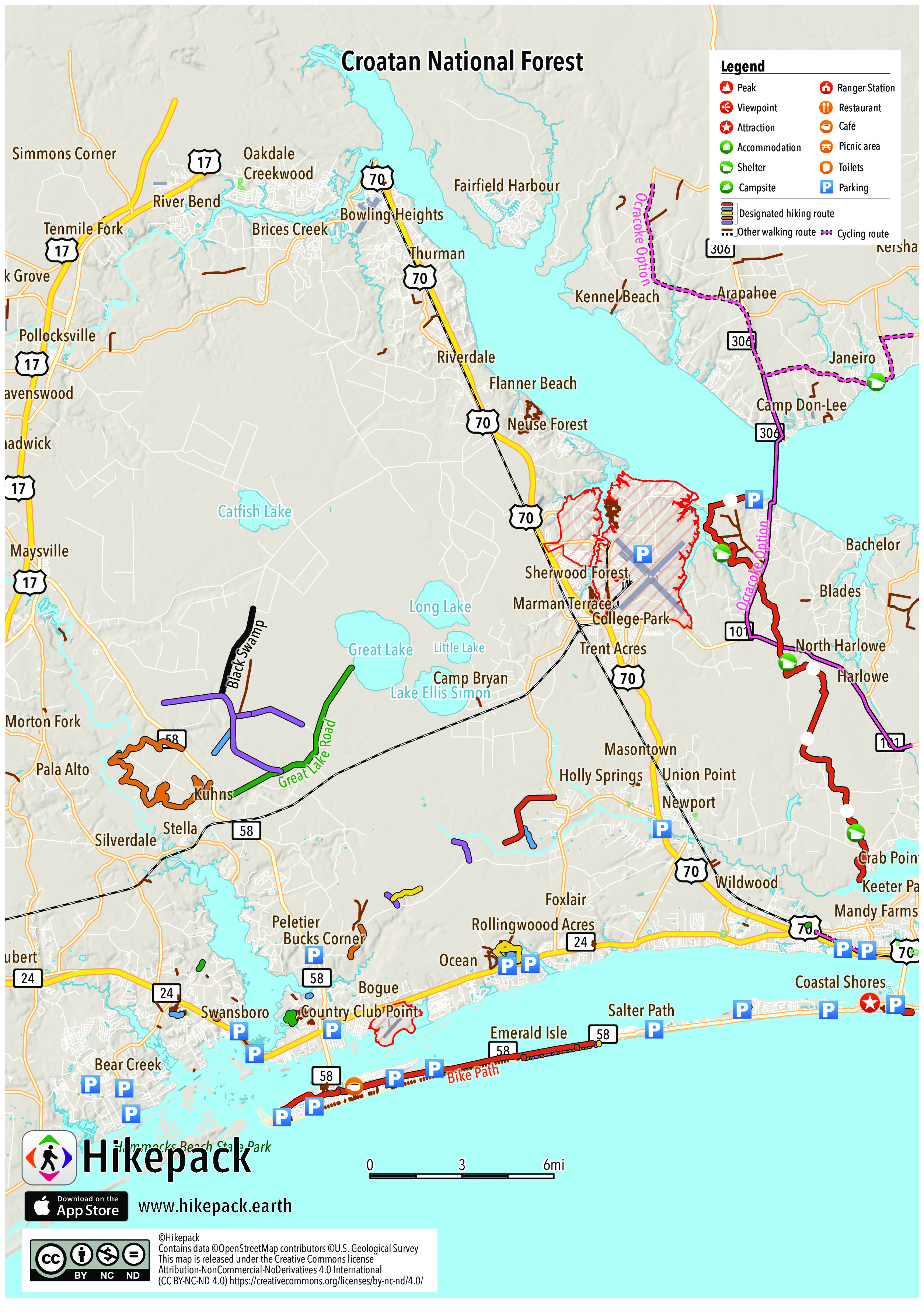
Croatan National Forest
150 Trails
606 POIs
41 Campsites
7 Picnic Sites
3 Viewpoints


Description
The Croatan National Forest is a U.S. National Forest, was established on July 29, 1936, and is located on the Atlantic coast of North Carolina. It is administered by the United States Forest Service, a part of the United States Department of Agriculture. The forest is managed together with the other three North Carolina National Forests (Nantahala, Pisgah, and Uwharrie) from common headquarters in Asheville, North Carolina. However, Croatan has a local ranger district office in New Bern. Many hiking trails can be found throughout the Croatan Forest such as the Neusiok Trail which offers 21 miles (34 km) of trail through swamps and pine forests. Other trails include the Cedar Point Tideland Trail which traverses through a salt marsh and along the White Oak River, the Island Creek Forest Walk featuring a forest of hardwoods, and the Black Swamp OHV Trail which offers eight miles (13 km) for off-road vehicles and bikes. The 13 mile long Catfish Lake Rd. provides many roads and trails for you to explore. In addition there is also a 14.1 mile trail, called the Weetock trail starting at the entrance to Long point landing road along NC Hwy 58 and continuing through the woods towards the Whiteoak river and turning around to end back on Hwy 58 roughly a quarter mile from the start point.
Trails in the Hikepack map
- 100
- 1000
- 1100
- 1200
- 1300
- 1400
- 1500
- 1600
- 1700
- 1800
- 1900
- 200
- 2000
- 2100
- 2200
- 2300
- 2400
- 2500
- 400
- 500
- 600
- 700
- 800
- 900
- Belangia
- Bike Path
- Black Skimmer Road
- Black Swamp
- Blue Trail
- City-to-the-Sea
- Dudley
- East Coast Greenway complementary route (NC/VA)
- Great Lake Road
- Green Trail
- Holston Creek Road
- Horse Island
- Landfall Ct
- Marsh Harbour Dr
- Millis Swamp
- Millis Swamp Spur
- Mountains-to-Sea Trail
- Neusiok Trail
- North Carolina Aquarium Nature Trail
- Ocracoke Option
- Pettiford Creek
- Pinewood Street
- Ports of Call
- Public Beach Access Path
- Scott Place Road
- Seaborn
- Seaborn Road
- South Gulley Branch
- The Point
- Tidelands Trail
- Tunnel Lane
- Vashti Drive
- Walking path
- Weetock Trail
- Yellow Trail
Attractions in the Hikepack map
- 1
- 10
- 101 Convenience Center
- 11
- 12
- 13 Host
- 14
- 15
- 16
- 17
- 18A
- 18B
- 19A
- 19B
- 2
- 21
- 22
- 24
- 25
- 26A
- 26B
- 27
- 28
- 29
- 3
- 30
- 31
- 32
- 33
- 34
- 35
- 36
- 3rd Street Park
- 4
- 4J's Cafe and Bake Shop
- 5
- 6
- 7
- 8
- 9A
- 9B
- Aquarium Employee Parking
- Aquarium Parking
- Arapahoe
- Ashley Place
- Atlantic Beach
- Atlantic Beach Seafood
- Atlantis Lodge
- Bachelor
- Battle Works - Tactical Laser Tag
- Bay Woods
- Bayshore Park
- Bear Creek
- Belgrade
- Black Jack Shelter
- Blades
- Bogue
- Bogue Inlet Motel
- Bogue Inlet Pier
- Bogue View Shores
- Bonham Heights
- Boro
- Bowling Heights
- Brices Creek
- Broad Creek
- Bucks Corner
- Bus Parking
- Camp Bryan
- Camp Don-Lee
- Camp Seagull
- Cape Carteret
- Carolina City
- Carolina Pines
- Carteret County Museum of History
- Carteret Historical Museum
- Cash Corner Number 2
- Cedar Point
- Chadwick
- Channel Marker Restaurant
- Chelsea Square
- China King
- Church Parking
- Circle Pizza and Subs
- Coastal Shores
- College Park
- Conner Village
- Copperhead Landing Shelter
- Country Club East
- Country Club Hills
- Country Club Park
- Country Club Point
- Crab Point Village
- Craven Corner
- Creekwood
- Croatan
- Cypress Shores
- Dank Burrito
- Debruhls Landing
- Dogwood Shelter
- Dollar General
- Dollar General Store
- Dollar Tree
- Dumpster
- Dunescape Condos
- Econo Lodge
- Edgewood
- El Zarape
- Emerald Grill
- Emerald Isle
- Emerald Isle Boat Ramp
- Emerald Isle Post Office
- Fairfield Harbour
- Family Dollar
- Flanner Beach
- Flanners Beach/Neuse River Campground
- Flipperz Bar & Grill
- Food Lion
- Fowle Post Office (historical)
- Fox Hollow
- Foxlair
- Full Moon restaurant
- Golden China
- Golfin Dolphin Golf Plane
- Goomba's Grill
- Granthams
- Great Wall
- Greenfields Heights
- Greenwood
- Hancock Village
- Handy Mart
- Harlowe
- Havelock
- Havelock Manor
- Havelock Park
- Havelock Post Office
- Havelock Station
- Haywood Farms
- Hedrick Estates
- Hilltop Acres
- Holly Hills
- Holly Springs
- Hollywood
- Host
- Hubert
- Hubert Post Office
- Ice House Waterfront Restaurant
- Indian Beach
- Islander Hotel & Resort
- Isle Fry Seafood Restaurant
- Jackie's American Grille
- James City
- Janeiro
- Jay Mini Mart
- Jerrett Estates
- Jones Corner
- Jordan's House of Seafood
- Just Coffee
- K & V Grocery Store
- K&V 1 Stop Shop
- Kangaroo Express
- Kathryn's Bistro & Martini Bar
- Keeter Park
- Kennel Beach
- Kershaw
- Ketner Heights
- Kuhns
- Lake and Shores Estates
- Lands End
- Lazzara's Pizza
- Lilliput Landing
- Lost Treasure Bumper Boats
- Lost Treasure Raceway
- Lowes Foods
- Main St Dock (public Access CAMA)
- Mandy Farms
- Manning Park
- Mansfield
- Manteo
- Marman Terrace
- Masontown
- Maysville
- Michealangelo's Pizza
- Mill Creek
- Minnesott Beach
- Mitchell Village
- Molly's Beachside Bar & Grill
- Morton Fork
- Musashi
- Neuse Forest
- Neusiok Trail
- New Visitors Center
- New York Deli
- Newport
- Nightmare Factory Haunted Attraction
- North Harlowe
- North Woods
- Oak Grove
- Oakdale
- Oaksmith Acres
- Observation Deck
- Ocean
- Ocean Crest
- Ocean View Inn
- Old Town Harbor
- On The Rocks
- Osaka Grill
- Pala Alto
- Parking for public park
- Pebble Beach
- Pebble Beach Gate
- Peletier
- Pho Saigon
- Piggly wiggly
- Pine Grove
- Pine Knoll Shores
- Pizza & Subs
- Plaza Mexico Restauarant Bar & Grill
- Point Emerald Villas
- Pollocksville
- Publix
- Pugliese Pavilion
- Queens Court
- Ravenswood
- Red Barn
- Rhems
- Ribeye's Steakhouse
- River Bend
- Riverdale
- Rollingwoood Acres
- Rucker John's Restaurant
- Rusty Pelican Motel
- Salter Path
- Saltwater Grill
- Santorini's Mediterranean Grille
- School Bus Parking
- Sea Shore Motel
- Seahawk Inn & Villas
- Sherwood Forest
- Shop
- Silverdale
- Simmons Corner
- Slocun Village
- Snug Harbor
- Sound of the Sea
- Spooners Creek East Harbor
- Spooners Creek Harbor
- Spooners Creek North
- Staff Parking lot
- Starling
- Station Street Park
- Stella
- Sunrise Point
- Swansboro
- Swansboro Food & Beverage Company
- Table 9
- Tenmile Fork
- The Clam Digger
- The Crab Shack
- The Crab's Claw
- The Trading Post
- The Village Market
- TheJavaPost
- Thurman
- Trade Wilco
- Trent Acres
- Trent Fuel Market
- Trent Shores
- Trent Woods
- Union Point
- Visitors Center
- Walmart Neighborhood Market
- Walmart Supercenter
- Wildwood
- Wilson Creek Heights
- Yana's Ye Olde Drugstore
Copyright
The PDF and JPG maps are released by Hikepack under the Creative Commons license Attribution-NonCommercial-NoDerivatives 4.0 International (CC BY-NC-ND 4.0)
https://creativecommons.org/licenses/by-nc-nd/4.0/.
Contains data ©OpenStreetMap contributors (https://www.openstreetmap.org/copyright) under the Open Database License (https://opendatacommons.org/licenses/odbl/). Topographic map based on elevation data from the U.S. Geological Survey. Aerial imagery available from the U.S. Geological Survey. Description text is available under the Creative Commons Attribution-ShareAlike 3.0 Unported License from Wikipedia (https://en.wikipedia.org/wiki/Wikipedia:Text_of_Creative_Commons_Attribution-ShareAlike_3.0_Unported_License). Cover image ©Bill Lea https://commons.wikimedia.org/wiki/File:Patsy_pond_croatan_nf.jpg Public Domain.