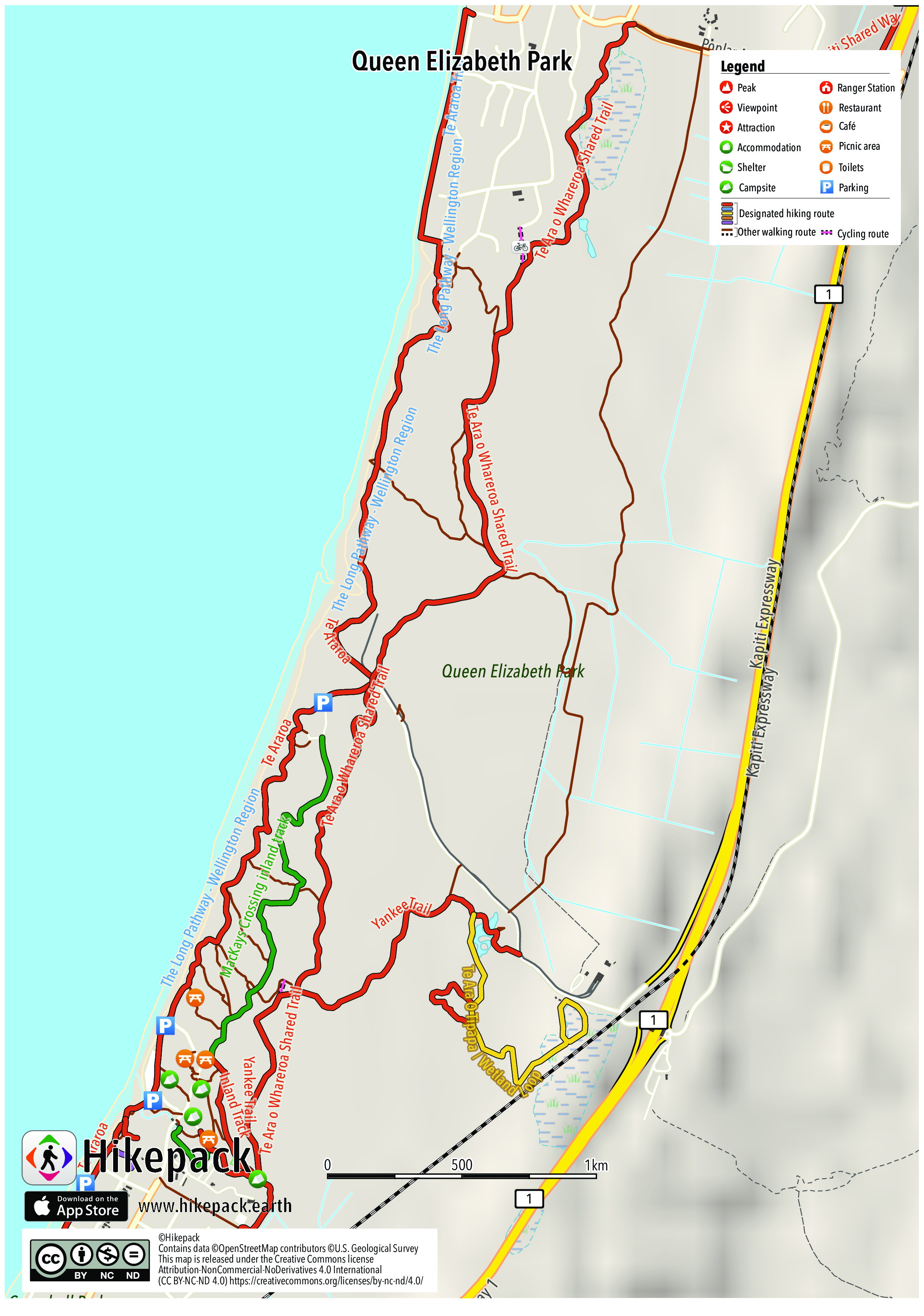
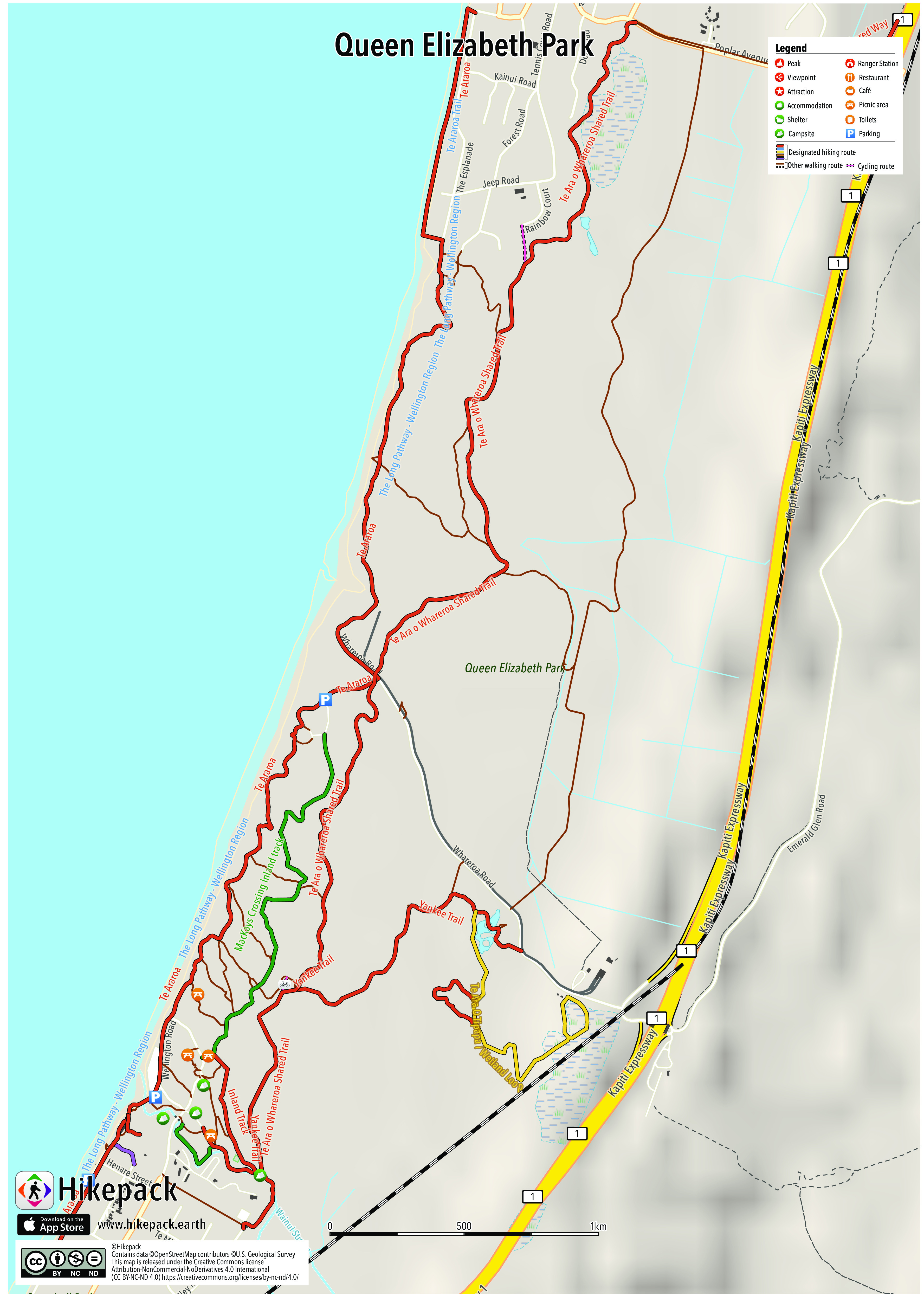
Queen Elizabeth Park
22 Trails
59 POIs
6 Campsites
8 Picnic Sites
2 Viewpoints


Description
Queen Elizabeth Park is a Wellington Regional Park located on the Kapiti Coast in New Zealand. The park contains the last area of natural dunes on the Kapiti Coast. The park is steeped in history including pa sites at Whareroa Beach and Wainui Beach. The park is bordered by Paekakariki, Raumati South, State Highway One, and the North Island Main Trunk Railway. Entrances are near the bridge of State Highway One over the railway (MacKay's crossing, main entrance) and in Raumati South and Paekakariki. The tangata whenua of the park are Ngati Haumia, a hapu of the Ngāti Toa iwi and Te Atiawa ki Whakarongotai. Several expansive lawn areas near Whareroa Beach and the southern entrance at Paekakariki provide plenty of space for picnics and recreational activities. Public toilets are located at the car parks at the end of the road to Whareroa Beach, and near the playground and car parks at the Paekakariki entrance. A coastal walkway and an inland walkway run the length of Queen Elizabeth Park from Raumati South to Paekakariki. Near the main entrance, a loop walkway leads through a wetland area and bush remnant with mature kahikatea.
Trails in the Hikepack map
- Beach Access
- Beach access
- Inland Track
- Kahikatea Remnant Bush Walk
- Kapiti Shared Way
- MacKays Crossing Coastal Track
- MacKays Crossing inland track
- Te Ara O Tipapa / Wetland Loop
- Te Ara o Whareroa Shared Trail
- Te Araroa
- Te Araroa Trail
- The Long Pathway - Wellington Region
- Wainui Stream Track
- Yankee Trail
Attractions in the Hikepack map
- Dog doo bin
- Memorial Lookout
- Paekakariki
- Paekakariki Holiday Park
- Wellington Road
- Wellington Tramway Museum
Copyright
The PDF and JPG maps are released by Hikepack under the Creative Commons license Attribution-NonCommercial-NoDerivatives 4.0 International (CC BY-NC-ND 4.0)
https://creativecommons.org/licenses/by-nc-nd/4.0/.
Contains data ©OpenStreetMap contributors (https://www.openstreetmap.org/copyright) under the Open Database License (https://opendatacommons.org/licenses/odbl/). Topographic map based on elevation data from the U.S. Geological Survey and NASA (SRTM 1 Arc-Second Global). This work is based on/includes LINZ's data (Aerial imagery) which are licensed by Land Information New Zealand (LINZ https://www.linz.govt.nz/) for re-use under the Creative Commons Attribution 4.0 International licence (https://creativecommons.org/licenses/by/4.0/). This work is based on/includes LINZ's data (NZ Topo 50) which are licensed by Land Information New Zealand (LINZ https://www.linz.govt.nz/) for re-use under the Creative Commons Attribution 4.0 International licence (https://creativecommons.org/licenses/by/4.0/). Description text is available under the Creative Commons Attribution-ShareAlike 3.0 Unported License from Wikipedia (https://en.wikipedia.org/wiki/Wikipedia:Text_of_Creative_Commons_Attribution-ShareAlike_3.0_Unported_License). Cover image ©Aidan Wojtas https://commons.wikimedia.org/wiki/File:Queen_Elizabeth_Park,_New_Zealand.jpg CC BY-SA 2.0 (https://creativecommons.org/licenses/by-sa/2.0/).